虽然之前早就有体验过MCP,但一直未介绍自己的实践过程,直到今天,我把自己在Trae里配置好的高德MCP拿出来,发了几个封沉已久的几个提示词:
城市图谱:用户输入城市后,AI输出城市的抽象地图,以及推荐吃喝玩乐路线
公园推荐:用户输入城市/区域后,AI输出这个区域的公园介绍
城市山峰:用户输入城市/区域后,AI输出这个区域的山峰介绍
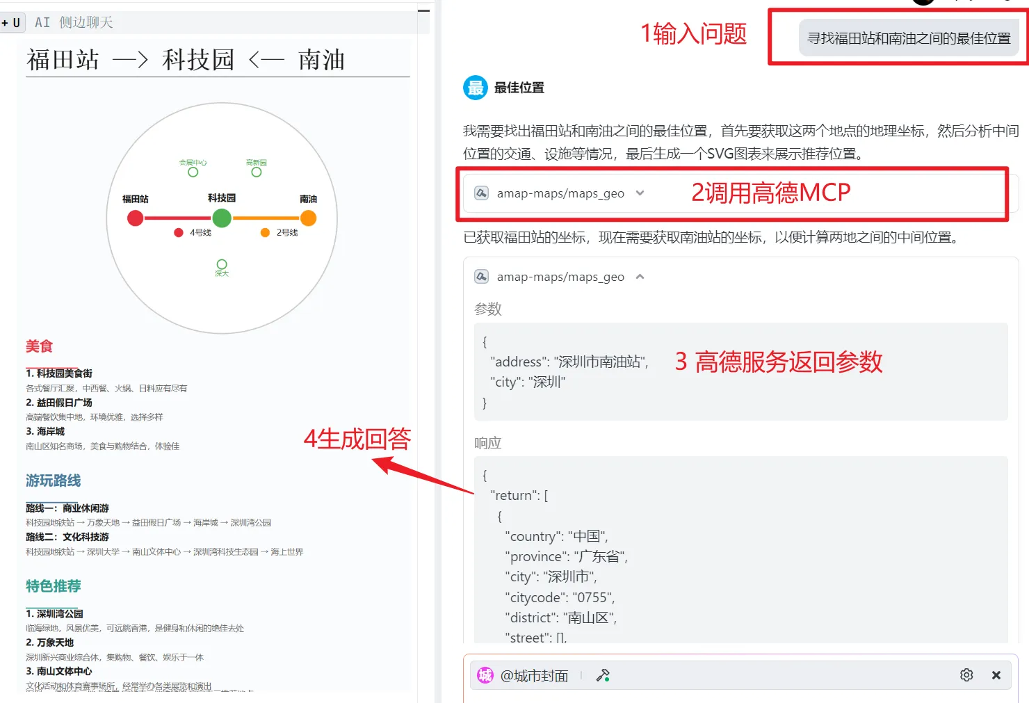
最佳位置:用户输入两个位置,AI推荐这两个位置之间的最佳选择
获得了如下几个卡片:
看到这个效果后,我人立马就精神了,这些生成结果因为是结合了高德地图返回的真实数据,内容更可靠.
如果说之前的仅靠模型输出结果的提示词是炫技,那么有了MCP调用能力的提示词就是真正能为用户提供实际价值。
这些卡片能精确定位到每个城市的具体区域,为用户推荐公园、山地和最佳位置。特别是最佳位置选择功能,解决了一个常见问题:当朋友A和朋友B分别在城市的不同位置时,想找一个对双方都方便、既好玩又交通便利的中间地点,单靠看高德地图往往很难决定。
借助高德MCP、大模型以及定制的提示词,用户只需发送两个位置,AI就能推荐出最佳的中间位置,而且所有数据都是真实可靠的。
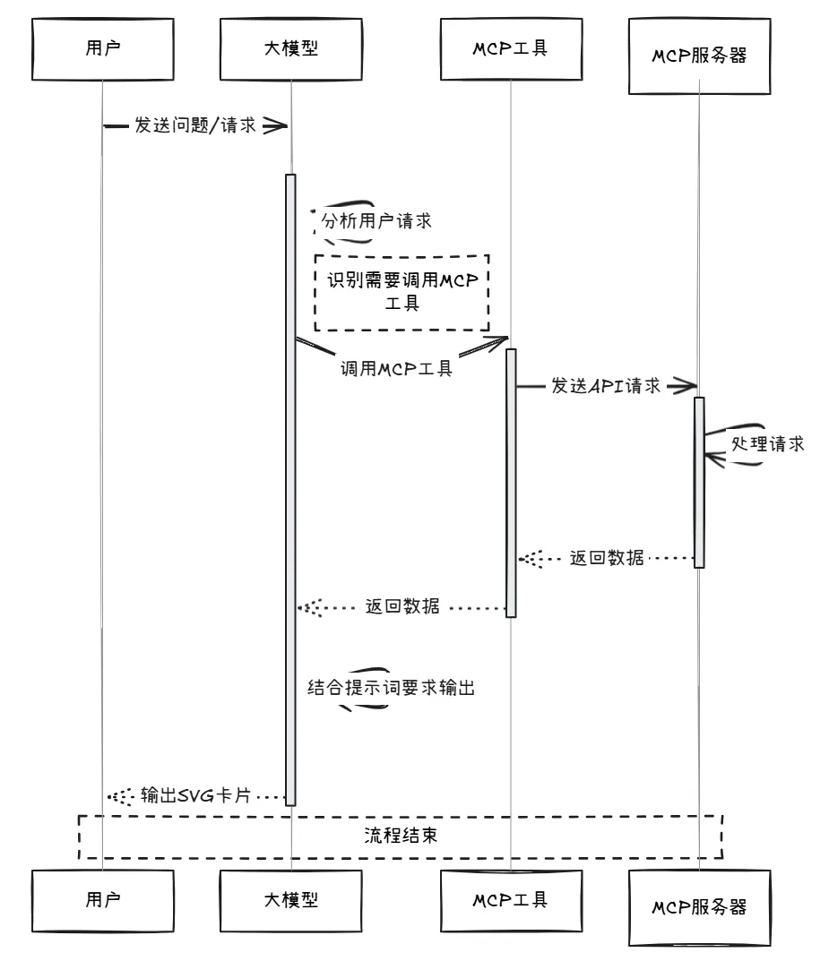
简单来说,实现原理是这样的:当我发送问题给大模型时,它会调用MCP工具向MCP server发送请求。MCP server返回数据后,大模型结合提示词的要求,将数据处理成一张SVG卡片输出。 假如没有MCP,也是能够输出好看的SVG的,只是生成的内容很不可靠。
MCP,全称模型上下文协议,是Anthropic开发的一个开放标准,旨在让AI模型(如大型语言模型)轻松连接到外部数据和工具。想象它像一个通用接口,让AI能实时访问文件、数据库或应用程序,而无需为每个工具单独编写代码。
例如,AI助手可以通过MCP从GitHub拉取代码,或在Slack中发送通知,简化了集成过程。
如果需要实现AI助手调用MCP工具,只需要在AI助手端配置好MCP就好了。
在配置过程中,我们需要理解三个问题
哪里可以配置MCP?
这一问题对应的是MCP client的概念,也就是支持配置MCP的 AI 助手,用户在MCP client 输入内容,AI都会调用MCP输出结果。
目前常用的MCP 有 cursor、Trae、Windsurf、Cherry studio等

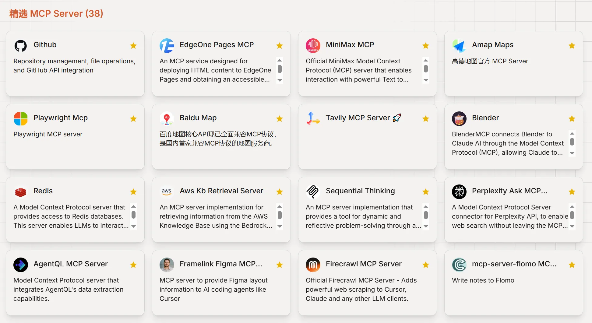
有哪些MCP可以配置?
这一问题对应的是MCP server 的概念,这通常由个人应用、To B应用官方开放的接口,或由其他开发者整合的接口实现。
比如高德地图的MCP就是高德自己开放的MCP 的服务,要使用它,就要申请高德的API key,配置好后,请求的信息,都是高德的服务返回来的。
目前可配置的MCP可以在 mcp.so[1] 网站查看:
怎么配置MCP?
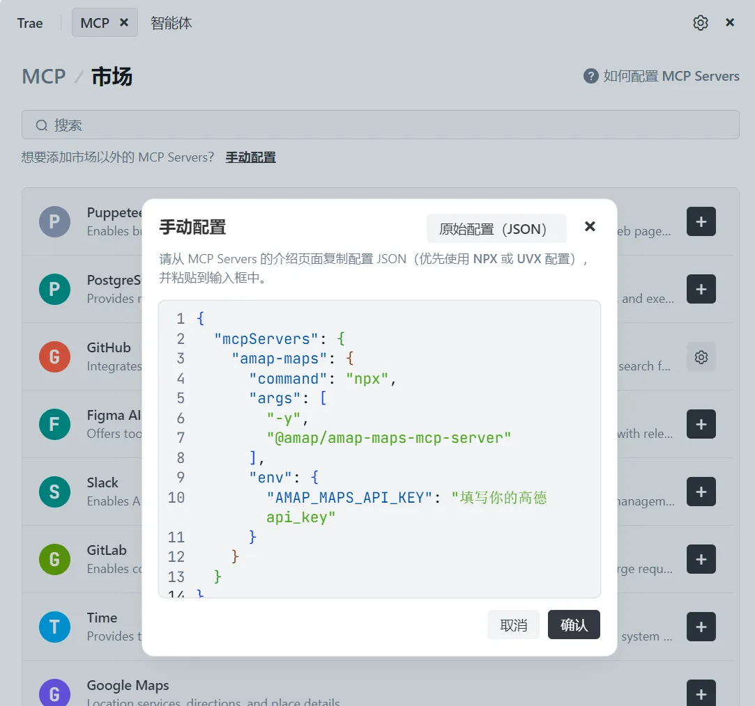
这里拿高德的 MCP server,Trae作为MCP Client 给大家举例。推荐各位使用Trae,这是字节推出AI 编辑器,免费且中文友好。步骤如下:
复制下面代码
{
  "mcpServers": {
    "amap-maps": {
      "command": "npx",
      "args": [
        "-y",
        "@amap/amap-maps-mcp-server"
      ],
      "env": {
        "AMAP_MAPS_API_KEY": "填写你的高德 api_key"
      }
    }
  }
}
打开Trae,点击右上角:头像——AI功能——MCP
点击:添加——手动配置,粘贴上面复制的代码
在下面网站,按高德要求申请官方的API key
https://lbs.amap.com/api/mcp-server/create-project-and-key
把获取到的 API key粘贴到第三步中“AMAP_MAPS_API_KEY”:
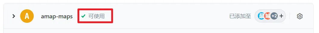
确认保存,看到可使用就证明配置完成了。
如何用好MCP?
最后,我们有了高德MCP要如何才能用好?
首先我们要知道高德MCP能够返回什么数据,我们才能用好这些数据,一般MCP server返回的都是json格式的结构化数据,最好的方法是在mcp.so搜索MCP server 查看使用说明。
接下来,我们可以在 TRAE 或 Cursor 中使用高德 MCP。通过定义智能体,我们可以配置提示词并调用 MCP 工具。这样,模型就能获取 MCP 返回的数据,并根据提示词的要求,输出用户所需的内容。
比如我文章开头的几个卡片,就是配置了四个智能体,智能体里定义了SVG卡片的提示词,开启高德MCP选项。
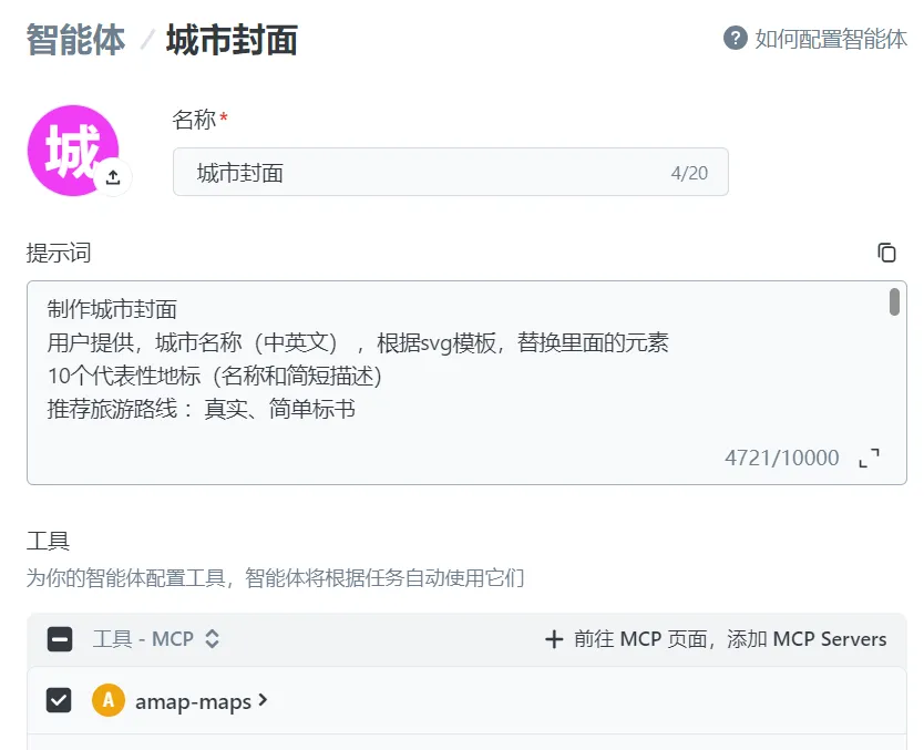
用好的关键还在于提示词的编写。我总共配置了四个MCP的提示词,就是开头介绍的,你也可以根据自己的需求,再结合高德地图MCP的能力来定义提示词。
提示词内容太长,如果需要这四个提示词,可以转发文章,截图发送到后台,将自动回复这四个提示词。
如果觉得有帮助,欢迎点赞、转发和再看。
点击阅读原文,加入AI-PAC 社群,让AI成倍提升个人效率和能力。
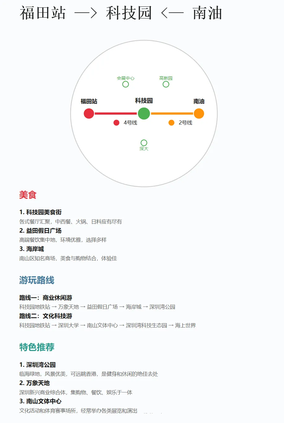
1. 图谱布局:- 800x1200的画布- 顶部标题:"位置1 —> 推荐位置 <— 位置2"- 中间地图:绘制从位置1到中间位置再到位置2的路线图- 底部推荐:推荐美食、游玩路线
开始时询问用户:请输入两个位置
参考下面SVG:
<svg viewBox="0 0 800 1200" xmlns="http://www.w3.org/2000/svg"><rect width="800" height="1200" fill="#fafbfc"/><g transform="translate(60, 60)"><text font-size="42" font-weight="bold" fill="#1a1a1a" style="font-family: 'SimSun', serif;">红山 —> 大学城地铁站 <— 西丽</text><line x1="0" y1="15" x2="680" y2="15" stroke="#333" stroke-width="1"/></g><g transform="translate(400, 320)"> <circle cx="0" cy="0" r="200" fill="#ffffff" stroke="#cccccc" stroke-width="2"/><path d="M -150,0 L 0,0" stroke="#e62d3b" stroke-width="6"/> <path d="M 0,0 L 150,0" stroke="#ff920b" stroke-width="6"/><circle cx="-150" cy="0" r="15" fill="#e62d3b" stroke="#ffffff" stroke-width="2"/><circle cx="0" cy="0" r="18" fill="#4CAF50" stroke="#ffffff" stroke-width="3"/> <circle cx="150" cy="0" r="15" fill="#ff920b" stroke="#ffffff" stroke-width="2"/><text x="-150" y="-28" text-anchor="middle" font-size="15" font-weight="bold" fill="#1a1a1a">红山</text> <text x="0" y="-30" text-anchor="middle" font-size="16" font-weight="bold" fill="#1a1a1a">大学城地铁站</text> <text x="150" y="-28" text-anchor="middle" font-size="15" font-weight="bold" fill="#1a1a1a">西丽</text> <circle cx="-75" cy="25" r="8" fill="#e62d3b"/> <text x="-55" y="30" font-size="14" fill="#1a1a1a">5号线</text> <circle cx="75" cy="25" r="8" fill="#ff920b"/> <text x="95" y="30" font-size="14" fill="#1a1a1a">7号线</text> <circle cx="-50" cy="-80" r="8" fill="none" stroke="#4CAF50" stroke-width="2"/><text x="-50" y="-92" text-anchor="middle" font-size="12" fill="#4CAF50">深大</text> <circle cx="60" cy="-80" r="8" fill="none" stroke="#4CAF50" stroke-width="2"/><text x="60" y="-92" text-anchor="middle" font-size="12" fill="#4CAF50">中大</text> <circle cx="0" cy="80" r="8" fill="none" stroke="#4CAF50" stroke-width="2"/><text x="0" y="100" text-anchor="middle" font-size="12" fill="#4CAF50">塘朗山</text> </g><g transform="translate(60, 550)"> <text font-size="24" font-weight="bold" fill="#e63946">美食</text> <line x1="0" y1="30" x2="90" y2="30" stroke="#e63946" stroke-width="2"/> <g transform="translate(0, 45)"> <text font-size="16" fill="#1a1a1a" font-weight="bold">1. 大学城美食街</text> <text x="0" y="25" font-size="14" fill="#666"> 平价美食汇聚,各地风味小吃,深受学生欢迎</text><text x="0" y="50" font-size="16" fill="#1a1a1a" font-weight="bold">2. 塘朗Village</text> <text x="0" y="75" font-size="14" fill="#666"> 精致咖啡馆、甜品店和各式餐厅,环境优雅</text><text x="0" y="100" font-size="16" fill="#1a1a1a" font-weight="bold">3. 益田假日广场</text> <text x="0" y="125" font-size="14" fill="#666"> 中高端餐饮,日料、火锅、粤菜应有尽有</text></g></g><g transform="translate(60, 783)"> <text font-size="24" font-weight="bold" fill="#457b9d">游玩路线</text><line x1="0" y1="30" x2="90" y2="30" stroke="#457b9d" stroke-width="2"/><g transform="translate(0, 45)"><text font-size="16" fill="#1a1a1a" font-weight="bold">路线一:校园文化游</text><text x="0" y="25" font-size="14" fill="#666">大学城地铁站 → 中山大学 → 深圳大学 → 塘朗湿地公园 → 益田假日广场</text><text x="0" y="50" font-size="16" fill="#1a1a1a" font-weight="bold">路线二:户外运动线</text><text x="0" y="75" font-size="14" fill="#666">大学城地铁站 → 塘朗山公园 → 塘朗山顶观景 → 国际大学城运动场 → 大学城美食街</text></g></g><g transform="translate(60, 966)"> <text font-size="24" font-weight="bold" fill="#2a9d8f">特色推荐</text><line x1="0" y1="30" x2="90" y2="30" stroke="#2a9d8f" stroke-width="2"/><g transform="translate(0, 45)"><text font-size="16" fill="#1a1a1a" font-weight="bold">1. 塘朗山登山</text><text x="0" y="25" font-size="14" fill="#666">远眺深圳湾和香港,城市全景尽收眼底,日落景色绝佳</text><text x="0" y="50" font-size="16" fill="#1a1a1a" font-weight="bold">2. 深中大校园建筑</text><text x="0" y="75" font-size="14" fill="#666">现代化校园建筑群,融合了岭南文化特色,环境优美</text><text x="0" y="100" font-size="16" fill="#1a1a1a" font-weight="bold">3. 大学城图书馆</text><text x="0" y="125" font-size="14" fill="#666">现代化藏书设施,对公众开放,是学习和阅读的绝佳去处</text></g></g><g transform="translate(60, 1150)"> <text font-size="14" fill="#666">图例:○圆形表示地点位置 实线表示地铁线路 文字表示推荐地点</text></g></svg>
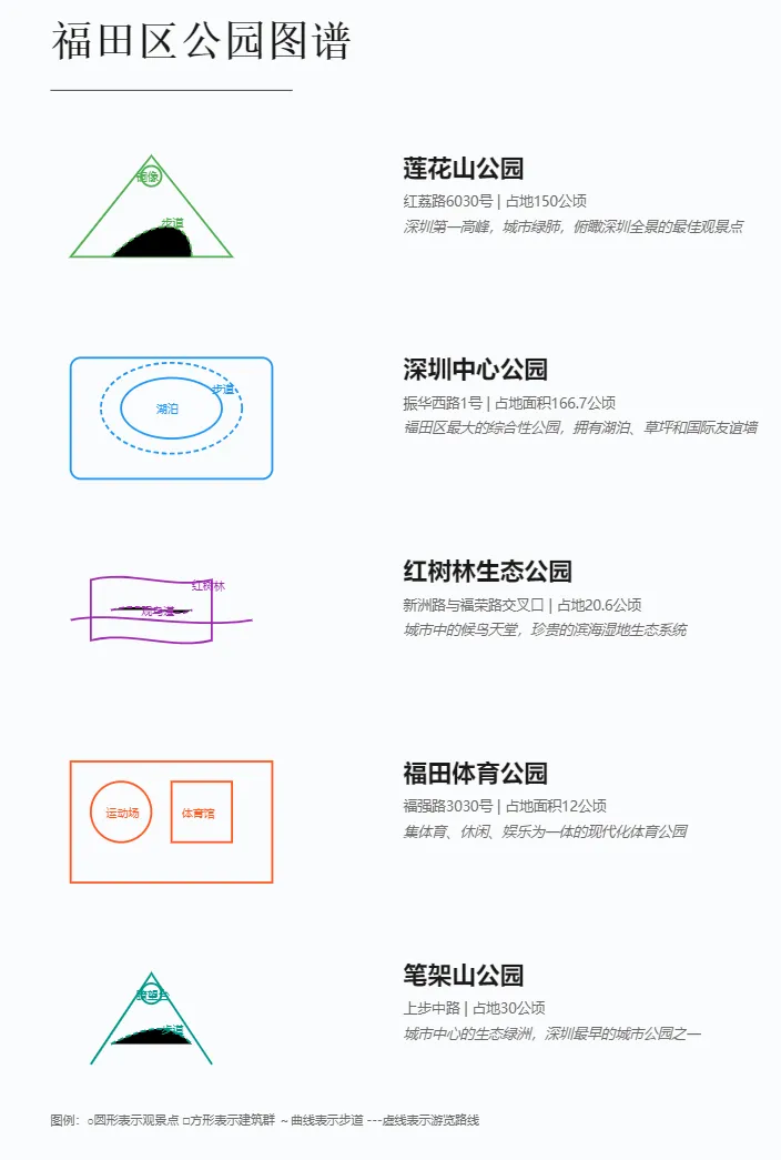
;;提示词:城市公园图谱生成器,
;;作者:空格的键盘
;;版本:v1.0
请为参考下方的SVG代码,为{城市名}创建一个SVG格式的公园图谱。要求如下:

1. 图谱布局:
- 800x1200的画布
- 顶部标题:"{城市名}公园图谱"
- 4-5个最具代表性的公园
- 每个公园占据独立区域,从上至下排列

2. 每个公园的展示要素:
- 左侧:简化的图形化表达
* 公园主要地形/布局
* 标志性景观/设施
* 主要游览路线
* 关键地标标注
- 右侧:文字说明
* 公园名称(24号字体)
* 地址和面积信息
* 特色简介(斜体)

3. 视觉风格:
- 每个公园使用不同的主题色
- 实线表示实体景观
- 虚线表示路径
- 圆形表示观景点
- 方形表示建筑群

开始时询问用户:请输入城市名

参考SVG
```
<svg viewBox="0 0 800 1200" xmlns="http://www.w3.org/2000/svg"><!-- 背景 --><rect width="800" height="1200" fill="#fafbfc"/><!-- 标题 --><g transform="translate(60, 60)"><text font-size="42" font-weight="bold" fill="#1a1a1a"
style="font-family: 'SimSun', serif;">深圳公园图谱</text><line x1="0" y1="35" x2="240" y2="35" stroke="#333" stroke-width="1"/></g>

<!-- 莲花山公园 --><g transform="translate(60, 140)"><!-- 图形部分 --><g transform="translate(0, 0)"><!-- 山体轮廓 --><path d="M 20,120 L 100,20 L 180,120 Z"
fill="none" stroke="#4CAF50" stroke-width="2"/><!-- 登山步道 --><path d="M 60,120 C 100,80 140,80 140,120"
stroke="#4CAF50" stroke-width="2"stroke-dasharray="5,3"/><!-- 邓小平铜像位置 --><circle cx="100" cy="40" r="10"
fill="none" stroke="#4CAF50" stroke-width="2"/>

<!-- 地标标注 --><text x="85" y="45" font-size="11" fill="#4CAF50">铜像</text><text x="110" y="90" font-size="11" fill="#4CAF50">步道</text></g><!-- 右侧说明文字 --><g transform="translate(350, 40)"><text font-size="24" font-weight="bold" fill="#1a1a1a">莲花山公园</text><text x="0" y="30" font-size="14" fill="#666">
福田区红荔路6030号 | 占地150公顷
</text><text x="0" y="55" font-size="14" fill="#666" style="font-style: italic">
深圳第一高峰,城市绿肺,俯瞰深圳全景的最佳观景点
</text></g></g>

<!-- 深圳湾公园 --><g transform="translate(60, 340)"><!-- 图形部分 --><g transform="translate(0, 0)"><!-- 海岸线 --><path d="M 20,80 C 60,70 140,90 220,80"
fill="none" stroke="#2196F3" stroke-width="2"/><!-- 滨海步道 --><path d="M 20,60 C 60,50 140,70 220,60"
stroke="#2196F3" stroke-width="2"stroke-dasharray="5,3"/><!-- 观景平台 --><circle cx="120" cy="70" r="10"
fill="none" stroke="#2196F3" stroke-width="2"/>

<!-- 地标标注 --><text x="105" y="75" font-size="11" fill="#2196F3">观景台</text><text x="160" y="55" font-size="11" fill="#2196F3">海滨栈道</text></g><!-- 右侧说明文字 --><g transform="translate(350, 40)"><text font-size="24" font-weight="bold" fill="#1a1a1a">深圳湾公园</text><text x="0" y="30" font-size="14" fill="#666">
南山区滨海大道 | 占地面积13公里长
</text><text x="0" y="55" font-size="14" fill="#666" style="font-style: italic">
最美海滨长廊,尽览深港两岸风光,观赏红树林生态
</text></g></g>

<!-- 仙湖植物园 --><g transform="translate(60, 540)"><!-- 图形部分 --><g transform="translate(0, 0)"><!-- 园区轮廓 --><rect x="20" y="20" width="200" height="120"
fill="none" stroke="#FF5722" stroke-width="2"/><!-- 温室 --><path d="M 40,40 L 80,20 L 120,40 L 120,80 L 40,80 Z"
fill="none" stroke="#FF5722" stroke-width="2"/><!-- 植物区 --><circle cx="160" cy="60" r="25"
fill="none" stroke="#FF5722" stroke-width="2"/>

<!-- 地标标注 --><text x="60" y="60" font-size="11" fill="#FF5722">温室</text><text x="140" y="65" font-size="11" fill="#FF5722">植物区</text></g><!-- 右侧说明文字 --><g transform="translate(350, 40)"><text font-size="24" font-weight="bold" fill="#1a1a1a">仙湖植物园</text><text x="0" y="30" font-size="14" fill="#666">
罗湖区莲塘仙湖路160号 | 占地590公顷
</text><text x="0" y="55" font-size="14" fill="#666" style="font-style: italic">
华南地区最大植物园,集科研、科普、旅游于一体
</text></g></g>

<!-- 红树林生态公园 --><g transform="translate(60, 740)"><!-- 图形部分 --><g transform="translate(0, 0)"><!-- 海岸线 --><path d="M 20,80 C 60,70 140,90 200,80"
fill="none" stroke="#9C27B0" stroke-width="2"/><!-- 红树林区域 --><path d="M 40,40 C 80,30 120,50 160,40
L 160,100 C 120,110 80,90 40,100 Z"
fill="none" stroke="#9C27B0" stroke-width="2"/><!-- 观鸟栈道 --><path d="M 60,70 C 100,60 120,80 140,70"
stroke="#9C27B0" stroke-width="2"stroke-dasharray="5,3"/>

<!-- 地标标注 --><text x="90" y="75" font-size="11" fill="#9C27B0">观鸟道</text><text x="140" y="50" font-size="11" fill="#9C27B0">红树林</text></g><!-- 右侧说明文字 --><g transform="translate(350, 40)"><text font-size="24" font-weight="bold" fill="#1a1a1a">红树林生态公园</text><text x="0" y="30" font-size="14" fill="#666">
福田区滨海大道 | 占地20.6公顷
</text><text x="0" y="55" font-size="14" fill="#666" style="font-style: italic">
城市中的候鸟天堂,珍贵的滨海湿地生态系统
</text></g></g>

<!-- 笔架山公园 --><g transform="translate(60, 940)"><!-- 图形部分 --><g transform="translate(0, 0)"><!-- 山体轮廓 --><path d="M 40,120 L 100,30 L 160,120"
fill="none" stroke="#009688" stroke-width="2"/><!-- 环山步道 --><path d="M 60,100 C 100,80 120,80 140,100"
stroke="#009688" stroke-width="2"stroke-dasharray="5,3"/><!-- 瞭望台 --><circle cx="100" cy="50" r="10"
fill="none" stroke="#009688" stroke-width="2"/>

<!-- 地标标注 --><text x="85" y="55" font-size="11" fill="#009688">瞭望台</text><text x="110" y="90" font-size="11" fill="#009688">步道</text></g><!-- 右侧说明文字 --><g transform="translate(350, 40)"><text font-size="24" font-weight="bold" fill="#1a1a1a">笔架山公园</text><text x="0" y="30" font-size="14" fill="#666">
福田区上步中路 | 占地30公顷
</text><text x="0" y="55" font-size="14" fill="#666" style="font-style: italic">
城市中心的生态绿洲,深圳最早的城市公园之一
</text></g></g>

<!-- 图例说明 --><g transform="translate(60, 1120)"><text font-size="12" fill="#666">
图例:○圆形表示观景点  □方形表示建筑群  ~曲线表示步道  ---虚线表示游览路线
</text></g></svg>
```

输出格式:使用artifact语法,类型为SVG,确保代码规范和完整。
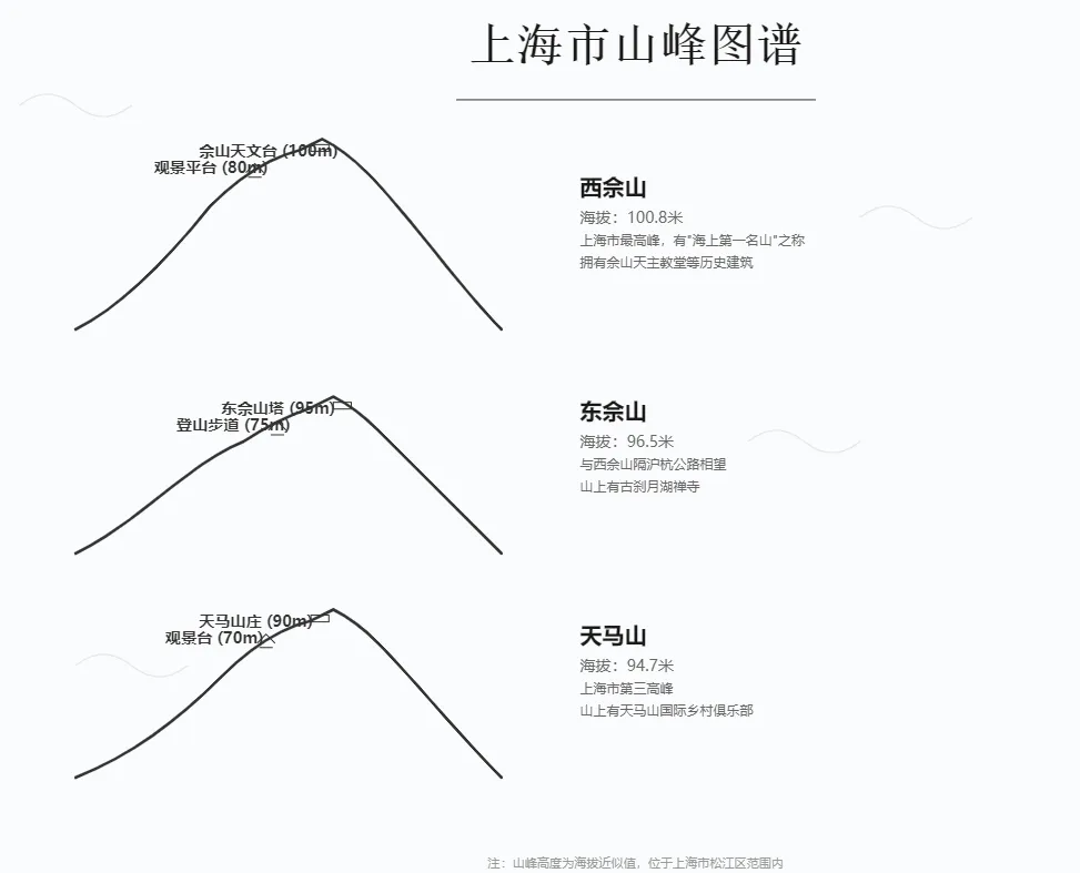
# 城市山峰图谱生成提示词
作者:空格的键盘
版本:v2

用户输入城市,根据以下格式为[城市名称]创建山峰图谱SVG图像。展示该城市最具代表性的3座山峰,突出地貌特征、文化地标和历史价值。

## 关键要求:
1. 图像规格:
- 尺寸:1200x800像素
- 背景:浅色系
- 布局:上中下三段式

2. 每座山峰展示元素:
- 特征化山形曲线
- 地标建筑标识
- 观景设施位置
- 海拔高度标注
- 文化特色说明

## 标准SVG模板:
````artifact
id: mountain_chart_v2
name: 城市山峰图谱
type: svg
content: |-
<svg viewBox="0 0 1200 800" xmlns="http://www.w3.org/2000/svg"><!-- 背景 --><rect width="1200" height="800" fill="#fafbfc"/><!-- 标题 --><g transform="translate(600, 60)"><text text-anchor="middle" font-size="42" font-weight="bold" fill="#1a1a1a"
style="font-family: 'SimSun', serif;">[城市名]山峰图谱</text><line x1="-160" y1="35" x2="160" y2="35" stroke="#333" stroke-width="1"/></g>

<!-- 山峰1(上部) --><g transform="translate(100, 120)"><!-- 山形曲线 --><path d="M 0,180
C 40,160 80,120 120,70
Q 160,30 200,20
L 220,10
Q 240,20 260,40
C 300,80 340,140 380,180"
fill="none" stroke="#333" stroke-width="2.5" stroke-linecap="round"/><!-- 地标建筑标注 --><g transform="translate(210, 15)"><rect width="16" height="6" fill="none" stroke="#333" stroke-width="1"/><text x="-100" y="10" font-size="14" fill="#333" font-weight="bold">[地标1] ([高度]m)</text></g><!-- 观景设施标注 --><g transform="translate(160, 40)"><path d="M -8,0 L 0,-8 L 8,0 M -6,4 L 6,4" fill="none" stroke="#333" stroke-width="1"/><text x="-90" y="0" font-size="14" fill="#333" font-weight="bold">[设施名] ([高度]m)</text></g><!-- 说明文字 --><g transform="translate(450, 60)"><text font-size="20" font-weight="bold" fill="#1a1a1a">[山名]</text><text x="0" y="25" font-size="14" fill="#666">海拔:[高度]米</text><text x="0" y="45" font-size="12" fill="#666">[特色描述1]</text><text x="0" y="65" font-size="12" fill="#666">[特色描述2]</text></g></g>

<!-- 山峰2(中部)结构类似 --><g transform="translate(100, 320)"><!-- 相同结构,调整山形曲线和标注位置 --></g>

<!-- 山峰3(下部)结构类似 --><g transform="translate(100, 520)"><!-- 相同结构,调整山形曲线和标注位置 --></g>

<!-- 装饰云纹 --><g opacity="0.15"><path d="M 50,100 Q 75,80 100,100 T 150,100" fill="none" stroke="#666" stroke-width="1"/><path d="M 800,200 Q 825,180 850,200 T 900,200" fill="none" stroke="#666" stroke-width="1"/><path d="M 700,400 Q 725,380 750,400 T 800,400" fill="none" stroke="#666" stroke-width="1"/><path d="M 100,600 Q 125,580 150,600 T 200,600" fill="none" stroke="#666" stroke-width="1"/></g>

<!-- 注释 --><text x="600" y="780" text-anchor="middle" font-size="11" fill="#999">
注:地标高度为海拔近似值,位于[城市名]市区范围内</text></svg>
````

## 地标标注规范:

1. 建筑类型标识:
```svg
<!-- 寺庙/庙宇 --><g transform="translate(x,y)"><path d="M -8,0 L 0,-8 L 8,0 L -8,0" fill="none" stroke="#333"/><text x="10" y="0">[寺庙名称]</text></g>

<!-- 观景台/平台 --><g transform="translate(x,y)"><rect width="12" height="6" fill="none" stroke="#333"/><text x="10" y="0">[平台名称]</text></g>

<!-- 索道/缆车站 --><g transform="translate(x,y)"><circle r="3" fill="none" stroke="#333"/><text x="10" y="0">[站点名称]</text></g>
```

2. 高度标注:
```svg
<g transform="translate(x,y)"><line x1="0" y1="0" x2="0" y2="20" stroke="#666" stroke-dasharray="2,2"/><text x="5" y="10">[海拔高度]m</text></g>
```

## 使用说明:
1. 输入城市名称后,选取该城市最具代表性的3座山峰
2. 确保每座山的描述包含:
- 历史文化价值
- 现代功能特色
- 标志性地标
- 观景价值
3. 地标标注要突出当地特色
4. 保持整体视觉平衡

开始时询问:请输入要生成山峰图谱的城市名称。
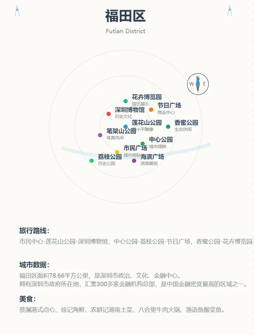
制作城市封面
用户提供,城市名称(中英文) ,根据svg模板,替换里面的元素
10个代表性地标(名称和简短描述)
推荐旅游路线 :真实、简单标书
城市文化特色简介 :数据化、冷知识
特色美食推荐 :美食名称

svg模板
```
<svg xmlns="http://www.w3.org/2000/svg" viewBox="0 0 600 800"><!-- 背景 --><rect width="600" height="800" fill="#fdfbf7"/><!-- 顶部标题区域 --><text x="300" y="50" font-size="32" font-weight="bold" text-anchor="middle" fill="#2c3e50">深圳市</text><text x="300" y="80" font-size="14" text-anchor="middle" fill="#7f8c8d">Shenzhen</text><!-- 平安金融中心装饰元素 - 颜色更淡 --><path d="M40,40 L45,15 L50,40" stroke="#3498db" fill="none" stroke-width="1" opacity="0.5"/><circle cx="45" cy="25" r="3" fill="#3498db" opacity="0.5"/><path d="M540,40 L545,15 L550,40" stroke="#3498db" fill="none" stroke-width="1" opacity="0.5"/><circle cx="545" cy="25" r="3" fill="#3498db" opacity="0.5"/><!-- 指南针 - 靠近地图 --><g transform="translate(470,200)"><circle cx="0" cy="0" r="25" fill="none" stroke="#2c3e50" stroke-width="1"/><path d="M0,-20 L5,0 L0,2 L-5,0 Z" fill="#3498db"/><path d="M0,20 L5,0 L0,-2 L-5,0 Z" fill="#7f8c8d"/><text x="0" y="-10" text-anchor="middle" font-size="10" fill="#2c3e50">N</text><text x="0" y="15" text-anchor="middle" font-size="10" fill="#2c3e50">S</text><text x="15" y="3" text-anchor="middle" font-size="10" fill="#2c3e50">E</text><text x="-15" y="3" text-anchor="middle" font-size="10" fill="#2c3e50">W</text></g><!-- 中部地图区域 --><g transform="translate(300,300)"><!-- 背景参考圈 --><circle cx="0" cy="0" r="180" fill="none" stroke="#e8e4df" stroke-width="1"/><circle cx="0" cy="0" r="120" fill="none" stroke="#e8e4df" stroke-width="1"/><circle cx="0" cy="0" r="60" fill="none" stroke="#e8e4df" stroke-width="1"/><!-- 深圳湾走向 --><path d="M-150,50 Q-50,80 50,70 Q150,60 200,40" fill="none" stroke="#a4d8ec" stroke-width="8" opacity="0.3"/><!-- 区域点和说明 --><g font-family="sans-serif"><!-- 1. 福田CBD --><circle cx="0" cy="0" r="5" fill="#3498db"/><text x="15" y="-5" font-size="14" fill="#34495e" font-weight="bold">福田CBD</text><text x="15" y="10" font-size="10" fill="#7f8c8d">金融中心</text><!-- 2. 华强北 --><circle cx="-40" cy="-30" r="5" fill="#e74c3c"/><text x="-25" y="-35" font-size="14" fill="#34495e" font-weight="bold">华强北</text><text x="-25" y="-20" font-size="10" fill="#7f8c8d">电子市场</text><!-- 3. 世界之窗 --><circle cx="-20" cy="60" r="5" fill="#f1c40f"/><text x="-5" y="55" font-size="14" fill="#34495e" font-weight="bold">世界之窗</text><text x="-5" y="70" font-size="10" fill="#7f8c8d">主题公园</text><!-- 4. 深圳湾公园 --><circle cx="40" cy="40" r="5" fill="#27ae60"/><text x="55" y="35" font-size="14" fill="#34495e" font-weight="bold">深圳湾</text><text x="55" y="50" font-size="10" fill="#7f8c8d">滨海公园</text>

<!-- 5. 南山科技园 --><circle cx="-60" cy="20" r="5" fill="#9b59b6"/><text x="-45" y="15" font-size="14" fill="#34495e" font-weight="bold">科技园</text><text x="-45" y="30" font-size="10" fill="#7f8c8d">创新中心</text>

<!-- 6. 东门老街 --><circle cx="60" cy="-40" r="5" fill="#e67e22"/><text x="75" y="-45" font-size="14" fill="#34495e" font-weight="bold">东门</text><text x="75" y="-30" font-size="10" fill="#7f8c8d">老街文化</text>

<!-- 7. 大梅沙 --><circle cx="100" cy="0" r="5" fill="#16a085"/><text x="115" y="-5" font-size="14" fill="#34495e" font-weight="bold">大梅沙</text><text x="115" y="10" font-size="10" fill="#7f8c8d">海滨浴场</text>

<!-- 8. 欢乐海岸 --><circle cx="20" cy="80" r="5" fill="#8e44ad"/><text x="35" y="75" font-size="14" fill="#34495e" font-weight="bold">欢乐海岸</text><text x="35" y="90" font-size="10" fill="#7f8c8d">娱乐综合体</text>

<!-- 9. 红树林 --><circle cx="-80" cy="80" r="5" fill="#2ecc71"/><text x="-65" y="75" font-size="14" fill="#34495e" font-weight="bold">红树林</text><text x="-65" y="90" font-size="10" fill="#7f8c8d">生态公园</text>

<!-- 10. 深圳书城 --><circle cx="0" cy="-60" r="5" fill="#1abc9c"/><text x="15" y="-65" font-size="14" fill="#34495e" font-weight="bold">书城</text><text x="15" y="-50" font-size="10" fill="#7f8c8d">文化地标</text></g></g><!-- 底部攻略说明 --><g transform="translate(50,550)"><!-- 旅行路线 --><text x="0" y="0" font-size="16" fill="#2c3e50" font-weight="bold">旅行路线:</text><text x="0" y="25" font-size="14" fill="#7f8c8d"><tspan x="0" dy="0">福田CBD-华强北-东门老街,世界之窗-欢乐海岸-深圳湾,红树林-大梅沙-科技园。</tspan></text><!-- 城市数据 --><text x="0" y="80" font-size="16" fill="#2c3e50" font-weight="bold">城市数据:</text><text x="0" y="105" font-size="14" fill="#7f8c8d"><tspan x="0" dy="0">平均年龄32.5岁,最年轻一线城市。深圳湾红树林面积368公顷,占全国24%。</tspan><tspan x="0" dy="20">拥有国家高新技术企业18650家,年专利申请量突破20万件,居全球城市第一。</tspan></text><!-- 美食推荐 --><text x="0" y="160" font-size="16" fill="#2c3e50" font-weight="bold">美食:</text><text x="0" y="185" font-size="14" fill="#7f8c8d"><tspan x="0" dy="0">潮汕牛肉火锅、老街客家菜、海鲜大排档。南园、东门是地道美食集中地。</tspan></text></g></svg>

```

开始时,询问用户,请输入城市名称